Broken Top
Broken Top
(9,175‘):
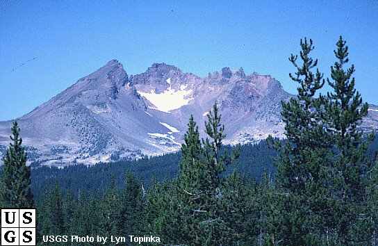 Broken
Top, like its more famous cousin to the North, Mt. St. Helens, forms a very
rough horseshoe. The similarity
ends there. Mt. St. Helens is a
young volcano whose shape is the result of a massive explosion.
Broken Top is a very old volcano whose shape is the result of an
implosion and the subsequent collapse of the summit.
Despite its geological age, Broken Top looks surprisingly young.
Ummm… I’m not exactly sure what that was supposed to mean but all
mountains look relatively the same age to me – old as shit!
Anyway, geologists theorize that the mountain is still standing because
of its position East of the Cascade crest.
With less snowfall, there has been correspondingly less erosion over the
years. Nevertheless, all of the
South side and much of the interior of Broken Top are gone. With the inside so easily visible, it is one of the better
examples of how volcanoes build themselves with alternating layers of pumice,
ash, and lava flow. There are 2
glaciers on Broken Top, the Crook glacier within the crater, and the Bend
glacier on the North side.
Broken
Top, like its more famous cousin to the North, Mt. St. Helens, forms a very
rough horseshoe. The similarity
ends there. Mt. St. Helens is a
young volcano whose shape is the result of a massive explosion.
Broken Top is a very old volcano whose shape is the result of an
implosion and the subsequent collapse of the summit.
Despite its geological age, Broken Top looks surprisingly young.
Ummm… I’m not exactly sure what that was supposed to mean but all
mountains look relatively the same age to me – old as shit!
Anyway, geologists theorize that the mountain is still standing because
of its position East of the Cascade crest.
With less snowfall, there has been correspondingly less erosion over the
years. Nevertheless, all of the
South side and much of the interior of Broken Top are gone. With the inside so easily visible, it is one of the better
examples of how volcanoes build themselves with alternating layers of pumice,
ash, and lava flow. There are 2
glaciers on Broken Top, the Crook glacier within the crater, and the Bend
glacier on the North side.
Descent:
The
only recommended descent in Summer and late Fall is down the Northwest Ridge or
the scree slopes of the West Face. The
best descent in Winter or Spring is a traverse South along the base of the rock
forming the West Crater Rim, to the top of Eleven O’Clock Couloir.
Downclimb the 50-degree gully for 500 feet, and walk South out of the
crater to Dutchman Flat Sno-Park or
Todd Lake. If Eleven O’Clock
Couloir looks dangerous or too steep, continue down to Nine O’Clock Couloir
and descend it. Under no conditions
should you descend the couloirs when they are bare of snow!
Northwest Ridge:
The
Northwest Ridge is the most popular climb on Broken Top because it is
technically easy and the rock is solid when it has to be.
Hmm… what about when it
doesn’t have to be and I still want it to be?
Approach from Green Lakes, or USFS 370 and 380.
From
Green Lakes, hike due East and follow a trail which leads to a saddle on the
Northwest Ridge just below 8,000 feet.
Use
USFS 370, USFS 380, and the trail to Green Lakes which skirts around the South
side of Broken Top, if you are looking for the fastest approach to Broken
Top’s Northwest Ridge. The
trail is slightly longer than Fall Creek Trail, but it starts 1,000 feet higher.
USFS 370 and 380 are not opened until the snow has melted and the roadbed
is dry. Sometimes this does not
occur until August!
From
the saddle in the Northwest Ridge, follow the trail up the ridge to the
Northwest corner of a 15-foot rock band. Climb
a large crack on good rock just left of the Northwest corner, or a dirty groove
about 20 feet South of the Northwest corner.
The climbing is short and easy, (fourth class or 5.1), but some may
prefer the security of a rope.
Move
up and right over a terraced scree-and-boulder field to a vertical wall that
forms the base of the summit pinnacle. Follow
a sloping ramp South along the wall. The
ramp rises gradually, and the wall shrinks in height. About 60 feet South, turn the South side of the vertical
wall, which is now little more than 6 feet high.
Follow the ramp North and scramble up horrible rock to the summit.
Time from Green Lakes, 2-4 hours.
A
variation includes a layer of hard rock, which caps the Northern end of the
summit pinnacle of Broken Top. It
also forms a ridge on the Northwest corner of the summit pinnacle, which
provides a delightful 50 feet of easy fifth class (5.2) climbing with just the
right amount of exposure.