Mount Hood
Mount Hood (11,239‘):
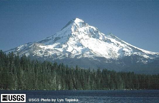 Mount Hood lies just South of the Columbia River and about 50 air miles
East of Portland, Oregon. It is the
highest mountain in Oregon, and its height is further accentuated by its
striking beauty and dominant position above the Columbia River.
Mount Hood is so prominent and well known that its image is used to
represent everything from the commercial to the sublime.
Mount Hood lies just South of the Columbia River and about 50 air miles
East of Portland, Oregon. It is the
highest mountain in Oregon, and its height is further accentuated by its
striking beauty and dominant position above the Columbia River.
Mount Hood is so prominent and well known that its image is used to
represent everything from the commercial to the sublime.
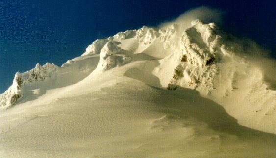
As anyone who has climbed the South Side of the mountain knows, Mount
Hood is a dormant, not a dead volcano. Signs
of recent volcanic activity are everywhere.
Geologists say that some of this activity occurred about 200 years ago
between 1760 and 1810, producing ashflows, mudflows, lava, and at least one
pyroclastic flow. All of these
events apparently originated from vents just above Crater Rock in the areas
known as Devils Kitchen and Hot Rocks. Because
thermal activity continues around these areas to this day, geologists believe
that “Liquid Hot MAGMA”, baby, yeah, is still present beneath Mount Hood,
and that further activity is very likely…
 Future geologic hazards are not the only threat to us. Geologists say that of the major Northwest volcanoes, only
Mt. St. Helens has a higher percentage of pyroclastics. Pyroclastics are loosely compacted fragmental material formed
during an explosive eruption. Climbing
on pyroclastics is similar to climbing on vertical rubble, you are never sure
what is going to pull loose and what else it will bring down on top of you.
Most of this type of rock is concentrated in the upper 4,000 feet of
Mount Hood, ample explanation for why Mount Hood isn’t known for it’s rock
climbing.
Future geologic hazards are not the only threat to us. Geologists say that of the major Northwest volcanoes, only
Mt. St. Helens has a higher percentage of pyroclastics. Pyroclastics are loosely compacted fragmental material formed
during an explosive eruption. Climbing
on pyroclastics is similar to climbing on vertical rubble, you are never sure
what is going to pull loose and what else it will bring down on top of you.
Most of this type of rock is concentrated in the upper 4,000 feet of
Mount Hood, ample explanation for why Mount Hood isn’t known for it’s rock
climbing.
A huge glacier smothered Mount Hood during the last ice age, and probably
removed at least 1,000 feet from the top of the mountain.
Scars on trees lining the Eliot Glacier show that current glaciers on the
North side of Mount Hood were extensive enough that ice could be collected
conveniently by the proprietors of Cloud Cap Inn to refrigerate food.
Glaciers on the South Side of Mount Hood were also advancing in the
recent past. Today the 11
named glaciers on Mount Hood are retreating, probably as a result of a
world-wide warming trend. Warmer
weather has also reduced the amount of permanent snow.
Despite poor rock and a diminishing snowbase, Mount Hood has the right
mix of accessibility, altitude, and variety.
The mountain is easily reached without the burden of organizing a major
expedition. In fact, we’ll most
likely either ride the ski lift up the first quarter of the mountain or step
from pavement onto glacier ice. It
is high enough to test y our abilities at altitude but low enough to descend
quickly in an emergency. The
variety of routes and snow conditions, if approached intelligently, gradually
expose the aspiring alpinist to the hard lessons of mountaineering.
Timberline Road leads to Timberline Lodge (roughly 5,960 feet), and
provides the best year-round access to routes on the West, South, and Southeast
sides of the mountain. In winter,
some climbers even use Timberline to approach climbs on the North side.
Drive to Government Camp Loop road, turn left onto the Timberline Road,
and drive about 6 miles to the Lodge parking area. Climbers can self-register 24 hours a day in a protected area
just outside Timberline’s Wy’east Day Lodge.
The day lodge is on the West
side of the upper end of the parking area.
When registering, climbers can also listen to a 24 hour weather forecast
on a radio, broadcasted by the National Weather Service.
Pundits claim that the South Side of Mount Hood is the
most-climbed mountain route in the world, with the exception of Mount Fuji in
Japan. To anyone who has climbed
the South Side on a good weekend in May or June, this claim seems to be
irrefutable fact. The mountain is
crowded, and getting form the top of the Hogback to the summit often requires
waiting in line.
According to the latest USFS records, somewhere between 20,000 and 25,000
climb Mount Hood every year. The
USFS also states that these numbers do not accurately reflect the actual number
of people on the mountain, because many parties choose not to sign in.
Although there are no official estimates, most of the people who climb
Mount Hood climb the South Side.
Many climbers also believe that the South Side is an easy climb which can
be done by senior citizens carrying 200-pound packs and preschoolers
unaccompanied by their mommies or daddies.
The written record does show that in the right conditions, almost anyone
can slog up this route. Over the
years many couples have climbed the South Side and been married on the summit.
Ivan Woolley states in Off To Mt.
Hood,
Upon two occasions the Knights of Columbus engaged Ray Conway to guide
parties from their lodge up the mountain and each time Ray packed an altar on
his back all the way to the top so that mass could be held on the summit.
Material to build a fire lookout was packed up the South Side
by the USFS in 1916. When the
lookout finally collapsed in the forties, a group of Crag Rats hauled loads of
powdered rubber from recapped tires to the summit and set the remains on fire.
Ty and Marianna (Sinclair) Kearney and their party packed a bicycle up
the South Side and rode it along the summit ridge in 1947.
The South Side has been climbed by blind people and people without limbs.
At least 2 five-year-old children have climbed the South Side under their
own steam. Uncounted senior
citizens, some in their eighties, have reached the summit.
50th anniversary climbs are not uncommon and one gentleman,
Hank Lewis, made his 64th anniversary climb in 1986.
A dog, Ranger, holds the record for the most ascents of the South Side,
estimated at over 1,000!!! When he
died, his body was packed up the South Side and buried on the summit.
Wild animals, including bear and deer, have also been observed climbing
or descending the South Side.
Ironically, the gentle, broad slopes which are so simple to climb in good
weather become windy, whited-out hell in bad weather.
Trapped on the South Side in such conditions, it matters little whether
you can ace 5.14 on sight or Downclimb vertical rime ice backwards and
upsidedown. Climbing is reduced to the basics of navigation and survival.
Anyone planning to climb Mount Hood must be familiar with the South Side
and how to get down it in a storm (See Descent).
Descent:
The South Side is the only recommended descent from the summit of Mount
Hood in an emergency or storm. Time
from summit to car, roughly 4-5 hours. Portland
Mountain Rescue distributes a 2-page brochure on how to get down the South Side
in low-visibility conditions. Anyone
climbing Mount Hood should read and understand this brochure (some of which is
quoted below).
CLIMBERS BEWARE OF THE
MT. HOOD TRIANGLE
Most search and rescue operations on Mt. Hood are the result of climbers
becoming lost on their descent from the South Side route. Others have become lost while descending from camps at
Illumination Saddle.
The most common problem occurs when visibility becomes poor and climbers
descend without aid of map and compass, thinking that if they simply go back
downhill they will surely return to the lodge.
However, the fall line (route a ball would take if let roll down a slope)
from the base of Crater Rock down to about the elevation of the top of Palmer
Ski Lift, does not fall toward Timberline Lodge on the South, but rather,
Southwesterly in the direction of the Zigzag Canyon and the cliffs of
Mississippi Head.
An area of descent that has caused a number of people to become confused
and lost is the traverse around the East slopes of the base of Crater Rock.
Occasionally, a climber will drop too low on the traverse and descent
into the White River Glacier and canyon to the East of the route.
This is bad. Don’t do
this.
More often, climbers will traverse around Crater Rock, staying on the
correct descent route, but then glissade down the fall line to the Westerly,
unaware they are in trouble until they reach the canyons and cliffs below.
This is also bad. Don’t do this.
Carry a map and compass. Use
your compass and believe it! Once
you have descended around Crater Rock, it can be noted that by simply following
the direction of the Southerly end of the magnetic compass needle you will
descend very close to the ski lifts and Silcox Hut.
In low visibility the descent by your compass may seem strange in that
you will find yourself sidehilling considerably to the left as you descend from
Crater Rock to below 9,000 feet.
The South Side via the Hogback:
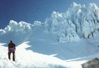 Start on the East side of the Timberline Lodge.
Do not follow the groomed ski trails; instead stay East in the trees and
hike 1mile to Silcox warming hut (approx. 7,000 feet).
Continue another mile to the end of the Palmer ski lift (approx. 8,600
feet). From the end of the ski
lift, climb toward the right or East side of Crater Rock, then continue around
and up the East side of the rock to the Hogback (approx. 10,600 feet), a high
ridge of snow extending from the North side of Crater Rock toward the summit.
Follow the Hogback to a large bergschrund.
If you don’t know what a bergschrund is, get the book, Freedom
of the Hills and read
it. Cross or go around the
bergschrund, depending on conditions. Enter
a gully, commonly called the Chute, which leads through several rock towers (The
Pearly Gates) to the summit ridge. Time
from Timberline Lodge, 6-10 hours.
Start on the East side of the Timberline Lodge.
Do not follow the groomed ski trails; instead stay East in the trees and
hike 1mile to Silcox warming hut (approx. 7,000 feet).
Continue another mile to the end of the Palmer ski lift (approx. 8,600
feet). From the end of the ski
lift, climb toward the right or East side of Crater Rock, then continue around
and up the East side of the rock to the Hogback (approx. 10,600 feet), a high
ridge of snow extending from the North side of Crater Rock toward the summit.
Follow the Hogback to a large bergschrund.
If you don’t know what a bergschrund is, get the book, Freedom
of the Hills and read
it. Cross or go around the
bergschrund, depending on conditions. Enter
a gully, commonly called the Chute, which leads through several rock towers (The
Pearly Gates) to the summit ridge. Time
from Timberline Lodge, 6-10 hours.
Be careful of
the cornice at the summit hanging over the North Face.
Interesting Quotes:
That night, hardly anyone in camp would say that they wished ever to
ascend Mt. Hood again. After a
nights rest several of us thought we might be willing sometime; and before we
had gone halfway home every member of the party had made some plan to climb
again.
Here’s a quote from the summit register that describes a small
section of one party’s amazing ascent of the hardest route on Mount Hood,
Yocum Ridge.
A mushrooming tower threatened progress and so Leo decided to try
the south flank. After chopping
downward and across a groove, he disappeared around a hidden corner.
Some 15 minutes later he came into view again, cutting up a gully-wall
that needed both hand and footholds.
Another description of this route describes a particularly harrowing
section of rappels and traverses on rime ice.
Contrary to what common sense would dictate, rime ice is more solid than
the rock on Yocum ridge. The catch
is that rime ice is often impossible to protect.
You can take your ice tools, pickets, and other technology, but know that
on this route the old school mountaineer advice still holds true; the leader
must NOT fall.
…the ramps quit, forcing the route up steep gullies and chimneys to the
Third Gendarme. Climb the ridge
crest of the Third Gendarme. The
Gendarme ends at an obvious drop-off next to a short rock pillar.
The pillar looks unstable, and probably is. Sling the pillar and rappel.