Mount Washington
Mountain
Description (7,794’):
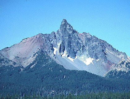 Mount Washington is an isolated
Basalt pinnacle on the crest of the Cascades between Santiam and McKenzie
Passes. Three prominent ridges
radiate North, West, and South from the base of the pinnacle. Large snowfields sometimes prevail on the East and West Sides
into July, but there are no glaciers or remnant glaciers.
Mount Washington is an isolated
Basalt pinnacle on the crest of the Cascades between Santiam and McKenzie
Passes. Three prominent ridges
radiate North, West, and South from the base of the pinnacle. Large snowfields sometimes prevail on the East and West Sides
into July, but there are no glaciers or remnant glaciers.
Evidence suggests that the name
Mt. Washington probably originated during construction of the Willamette Valley
and Cascade Mountain Military Road. The
road was built from Sweet Home east over Santiam Pass, and into Central Oregon,
and was completed in 1867. A series
of four maps were prepared by surveyor James A. Warner which showed the road in
relation to surrounding features. Clearly
labeled on the first map, and located several miles South of the pass, is
“Washington Peak” (Oregon State Archives 1871).
Mount Washington was originally
formed as a shield volcano. Later,
basalt invaded the shield and formed a basalt plug. Pleistocene glaciation stripped the outer debris, leaving the
plug much as we see it today. Rock
quality varies, but the West Face, West Ridge, South Face, Southeast Ridge, and
East Buttress all have good rock. Indeed,
Mount Washington is the only place in the Oregon Cascades where the alpine rock
climber might find happiness.
The best time to climb Mount
Washington is late Spring, Summer, and early Fall. The approach, the climb, and the return can easily be done in
a day. Winter ascents usually take
two days.
Water is difficult to find in
late Summer and Fall, the only year-round source being Coldwater Spring.
Hard hats are necessary, and you probably don’t want to be on a route
with a party climbing above you. Take
ice axes and crampons between November and June.
The decision whether to take rock shoes or mountain boots depends on
season and individual preference. We’ll
be bringing rock shoes…
Approach:
We’re taking the easiest way
to reach Mount Washington. Follow
US 20-126 to the Hoodoo Ski Bowl and Big Lake turnoff 1 mile West of Santiam
Pass. Turn South off US 20-126
toward Hoodoo Ski Bowl on USFS 2690. Follow
USFS 2690 4.2 miles to a trailhead on the West side of Big Lake.
Follow an unmarked trail along
the lake for 2 or 3 minutes, to a junction with a second trail called the
Patjens Lake Trail. Continue around
Big Lake until the trail leaves the shoreline.
At an obvious junction, turn left (east). (Continuing straight will lead away from Mt. Washington to
Patjens Lake). Head East for about
5 minutes. Several spur trails will
join the trail from the West, but continue East until the trail splits.
Take the right fork for 2 or 3 minutes to a clearing with a pile of dead
logs on its South side. (The left fork continues around the East side of Big Lake).
Turn right (South) in the clearing and follow a wide trail for 5 minutes
to its junction with the PCT. Follow
the PCT South for 30 minutes (or about an hour from the road head), to a
climbers’ trail which goes uphill to the East.
The climbers’ trail is usually marked by a cairn and is just after a
large rock on the left side of the trail. If
you reach Coldwater Spring, the only year-round water source on this section of
the PCT, you have missed the climbers’ trail and hiked about 10 minutes too
far. About 150 feet after leaving
the PCT, the trail splits. The
right fork can be used for gaining the West Ridge or routes on the South Face.
Follow the left fork until it breaks out of the timber onto the North
Ridge proper. Drop onto the East
side and contour around the base of the North Ridge for routes on the East Face.
Continue up the ridge for routes on the North and West Faces.
Descent:
The only recommended route off
of the summit pinnacle is down the North Ridge.
Descend Northeast toward Black Butte, a prominent, rounded cinder cone in
Central Oregon. After about 100
feet, cut West to a short 10-foot chimney.
Continue down easy rock and scree about 250 feet to a large boulder with
rappel slings. If you don’t mind
downclimbing easy rock, use one rope to rappel. Take two ropes to reach all the way to the notch in the North
Ridge. Glissade or run scree
(depending on season – we’re running scree) down the West side, and follow a
climbers’ trail to the PCT.
Central
Pillar Route Description (5.8+):
This route has 4 pitches and
it’s described as steep, exposed and a joy to climb. There are several 15 – 20 foot runouts, but the crux is
well protected. Take a #4 Friend or
its equivalent.
Climb
diagonal ramps toward the right side of the West face.
Belay on small ledges above the first belay for the West face and next to
an obvious crack which diagonals up and left.
Move left into the crack and follow it 40 feet to its end on top of a
block. Move right off of the block
and then face-climb straight up 110 feet to small belay ledges.
Move up 20 feet into a debris-filled gully.
Scramble about 250 feet up the right wall of the gully and along the West
Ridge to the summit.
Interesting
Excerpts From Summit Journals:
Among others was a solitary tower, or needle, of basalt, many hundreds of
feet high, standing by itself at the foot of the mountains, like some grim
sentinel at the foot of Olympian heights.
- George L. Woods observing Mt. Washington from North
Sister in 1857