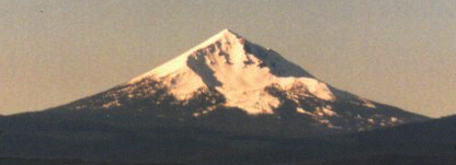
Mount McLoughlin, Oregon
The trad route starts from a parking area trail head located off Highway 140 approximately 35 miles west of Medford, or from an alternate trail head located off Four Mile Lake Road. Either way the route takes an approach to the east ridge of the mountain which climbs above the large glaciated bowl located on McLoughlin's northeastern face.
The view of McLoughlin from the 6000' level of the trail heads will start any climber's heart racing. The 3900' climb covers almost 5 miles distance, and if easier summer climbing isn't trilling enough, excellent winter access and parking is available with a Snow Park Pass at the Highway 140 trail head. Winter conditions on McLoughlin, as with any of the northwest Cascade volcanic summits, can change and deteriorate very quickly. Full mountaineering and technical climbing gear should be carried.